 Bibliopathos - Via Enrico Toti 1, 37129 Verona
100 books : The collection of a Gentleman 100 books : The collection of a gentleman
Friday 10 December 2021 hours 18:00 (UTC +01:00)
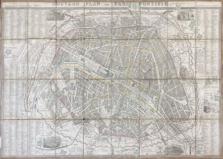
[Map, Travels] Paris, 1855
Nouveau plan de Paris fortifie . Paris : P. Marie et A. Bernard, 1855
1 colored folding map of the city of Paris (61x90 cm) . At margin the list of the street names.
Beautiful map of Paris printed shortly after the start of Haussmann's Paris transformation work.
It shows the two surrounding walls of Paris, the wall of the Fermiers Generaux, an enclosure built between 1784 and 1790, the objective of which was to allow the collection, at the crossing points, of a tax on goods entering the city, and the enclosure of Thiers, named after the politician who conceived the project, built between 1841 and 1844, at the request of Louis-Philippe, who wanted to build around the capital a bastioned enclosure which would make the city impregnable.
Beyond the enclosure of Thiers, one can see the 16 detached forts built at the same time as the enclosure (forts of Vincennes, Charenton, Ivry, Bicetre, Montrouge, etc.). These forts are represented by fortified walls in watercolor green. The city is divided into 12 arrondissements, the numbers of which are written on watercolor labels.
It was not until June 16, 1859, that the 20 arrondissements were created, when the suburbs located between the fortifications of the Thiers enclosure and the Wall of the Farmers General were annexed to Paris. Fourteen monument vignettes adorn the map: Arc de Triomphe, Bastille, Hotel de Ville, etc. The Seine is decorated with several boats. The plan also shows the railway lines illustrated with trains. Valley, 2053.


